

Use case:
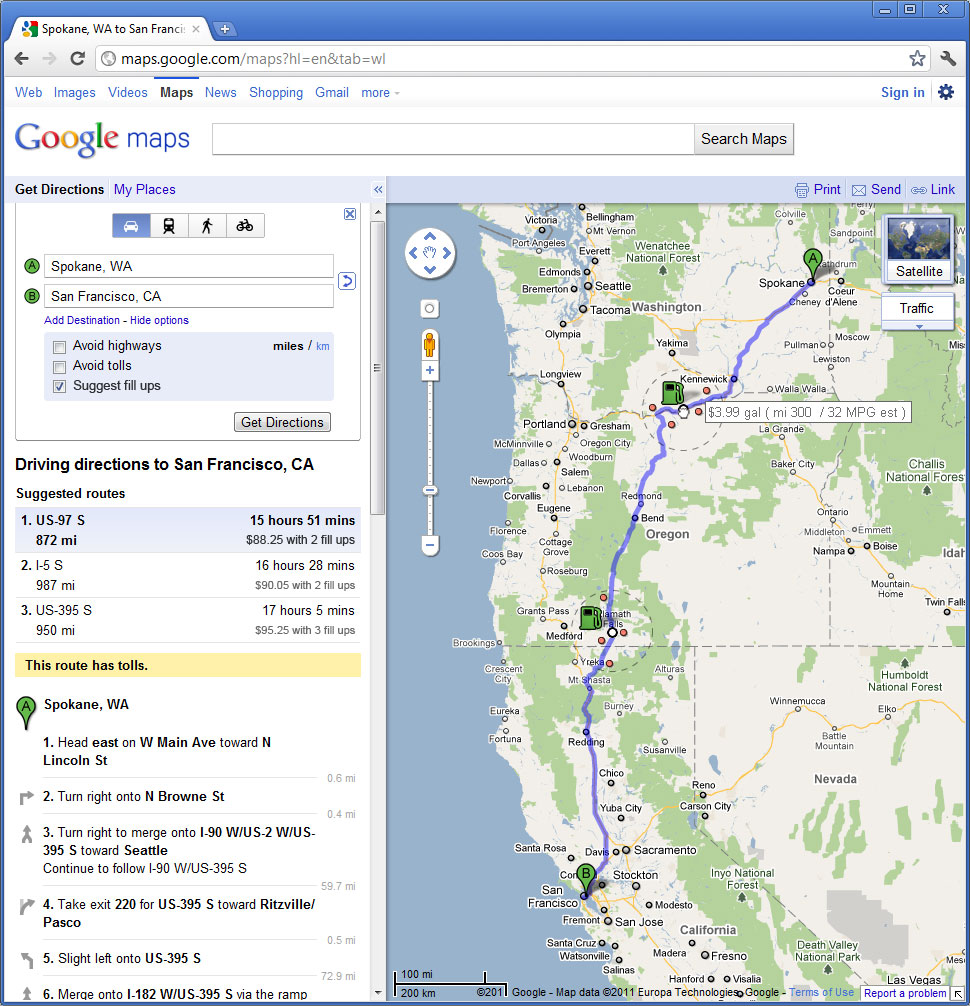
- A user uses "Get Directions" in Google maps and plots a route.
- User selects "Show options" then checks "Suggest fill ups" and clicks "Get Directions".
- The route is recalculated with an initial cheapest suggested route with additional possible routes.
- Suggested routes now also show total trip cost and number of fillups and behave like normal suggested routes with semi-transparent overlays on mouseover.
- The map now shows green gas icons at intervals throughout the trip indicating Googles suggested fill up locations.
- Each icon has a corresponding dot on the route and a dotted circle to indicate a definable range from the dot.
- Upon initial mouseover a tooltip appears stating "Drag to set Miles Per Gallon" (or Liter depending on region)
- When dragged data appears in the tool tip that auto updates. (both the MPG, distance along route, and cost of gas)
- As the icon is moved the distance between subsequent gas icons is shortened/lengthened to match relationally with additional fill ups added/removed as needed.
- When released, new fill ups are calculated, the route reset, average cost recalculated and route suggestions updated.
- For each icon a calculation is made that preferences cost of gas but factors in distance from route and ease of access of station (yielding a best location).
- At closer distances the user can see that a dot is placed on this best location and the trip route adjusted to provide direction.
- Other possible stations are also indicated within the dotted circle. On mouseover the station dots provide more information (as usual behavior) that might indicate food options or special features.
- The user can drag the station dot from one station to another. The dot snaps to each station, adjusting the route. When released the route is reset and average cost recalculated.
- The user can also drag the circle which expands from the origin of the gas icon. This increases the distance the user is willing to drive from their route to find cheaper gas. When released the route is recalculated including more options into its calculations. When this circle is widened the calculation should be adjusted with a higher preference for price and when it is narrowed, the distance from road should be preferenced (in addition to the area evaluated for both).
Notes:
- Gallon/Liter will change depending on countrys preference. If a trip crosses between opposing countries, the preference of the trips origin will be used for average cost and tooltip designations. Individual stations hover information retain their gallon/liter preference.
- I love the simplicity and cleanness of the Google maps application but to retain that certain decisions were made to initially exclude user defined settings. My goal was to incorporate all of the user settings into the icon interactions and not in the options panel. But in doing so I excluded a couple of options that may need to be added to the feature. The first is size of gas tank which is needed to calculate distance from MPG. My assumption for the mockup is that a functional average/standard could be established which satisfies the users needs but further research and testing is needed to establish this. The second is type of fuel (regular, diesel, biodiesel, electric, etc) as can be seen in my Map Search (Scenario 1c) example. This would broaden the feature and make it more earth friendly. Both settings could be established in a single line beneath the "Suggest fill ups" check box as an expandable more options widget.